
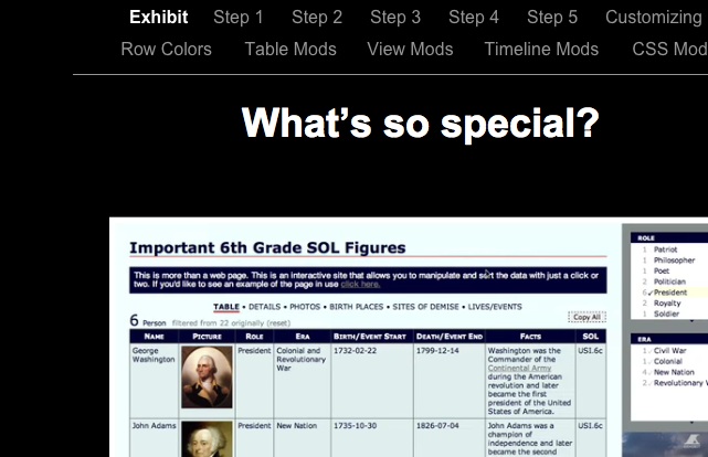
It took a while but I put together a fairly lengthy tutorial on how to make an Exhibit site that gets its info from a Google spreadsheet feed. It’s complete with tutorial files and a number of screencasts. I’m not sure it’s out of beta yet but I’m inviting anyone who’s interested to check out the tutorial and let me know if I’ve done anything stupid or made absolutely no sense in any portion (which is likely when trying to describe how the different view options work).
I tried to include a rationale for using the project with Millennials as well as step-by-step directions to get a basic working copy up and running. The customization piece was a lot harder to do w/o specific requests to cover. If you want to know how to do anything I didn’t cover feel free to contact me and I’ll throw up some more video.
I’d appreciate any feedback- good or bad.
Thanks,
Tom
That’s a really cool tool, Tom. I was thinking it would be great for studying literary figures, too. Your video, by the way, made it easy to see the possibilities involved.
Dana,
It is amazing what MIT people can do isn’t it? Plus it’s free. You have to love that (really, there’s no choice).
I like the literary figure idea. I wish there was a way to easily add paths to the maps as well as points (- TANGENT -there probably is but it seems like it’d be a hassle to plot the coordinates of each point). I wonder if it’d be possible to feed the lines in from a google mymaps site and have two different feeds of data on one map).
If a school was super organized it’d be interesting to set up a series of geographically and thematically overlapping novels across grades and subject areas. That way a student would build up this map of overlapping ideas and locations as they progressed through the year(s). It’d really show some connections then and everything would interrelate.
I’m thinking more and more of the possibilities of google earth and google maps as 3d indexes for learning. They have to potential to hold so much information now and make it geographically relevant and interactive at the same time.
Tom
this is scary cool!I had it bookmarked and just finally got time to look at it – I haven’t even had time to process it yet but I love it.
Dee,
That’s why I love the Internet! Were it not for the Internet, I’d be sitting here, all alone with no one to share my sheer amazement over how cool this. Now I don’t feel like half the nerd (still fairly nerdy but that’s ok) I might have. 🙂
I love this whole concept. It’s got potential beyond what I can imagine. It will be cool to see what people end up doing with it.
Tom